


Basics
- Length:
- 48 miles (77 km)
- Time:
- 1 hour to drive or a day and a half to enjoy the entire Byway.
- Fees:
- There are no fees along the Byway proper. There might be fees along various roads leading to the Byway such as the Kansas Turnpike.
Description
Come to the vast grassland empire that remains unspoiled by modern civilization. Walk the fields of wildflowers and waving grasses and scan the undulating prairie hills to distant purple horizons. Follow the trails of forgotten tribes and wagon trains rolling westward. Enter the domain of the rancher, the cowboy, and the herds of cattle grazing on the bluestem tallgrass. Glimpse the prairie chicken, the pronghorn, the white-tail deer, and the wild turkey that remain inhabitants of this yet wild land. Experience the solitude, the sounds of the untamed prairie, and breathe the fragrances in the fresh prairie wind. You will not soon forget your adventure in these eternal hills.
From Council Grove at the northern terminus, where you experience the stepping off point for the Santa Fe Trail, to the Prairie Chicken Capitol of Cassoday at the southern terminus, the Flint Hills Scenic Byway offers an endless horizon of the Tallgrass Prairie. Visit the Kaw Heritage National Park to learn the stories of the Native Americans, then visit the Kaw Mission State Historic Site to learn how the Natives and the Euro-Americans interacted. See the remains of the Council Oak where the treaty was signed allowing safe passage on the Santa Fe Trail, where wagon travelers could obtain supplies at the Last Chance Store, and then travel south on the byway to experience the expanse of the prairie from the window of your modern-day prairie schooner.
A stop at the Tallgrass Prairie National Preserve tells the story of man's stewardship of the natural beauty of the Flint Hills and provides an opportunity to see wildflowers and tallgrass up close. You can learn about the cattle industry on the Prairie and how the cattle are visitors to the land as well. Next, drive on to Cottonwood Falls to see the beauty of the Flint Hills limestone transformed into the Chase County Courthouse and other buildings in the downtown. From Cottonwood Falls south, stop at the scenic overlook to get a 360-degree view of the prairie. Afterward, drop down into the river valley to enjoy the beauty of the Pioneer Bluffs-Rogler Ranch Historic District and its limestone fences.
At the south end of the byway, enjoy the hospitality of the Cassoday Cafe where, on the first Sundays in May through October, over 3,000 motorcyclists gather for brunch before touring the byway. If you wish to extend your stay overnight, a trip on the Prairie Drifter from the Grand Central Hotel out onto the prairie will showcase not only the grassland beauty but also the beauty of the galaxies at night.
Tourism Resources
Helpful Links
Tourism Resources
Points of Interest
Points of Interest Along The Way
Al-le-ga-wa-ho Heritage Park (KS)
The Kaw Heritage Park is a beautiful and historic 158-acre park owned and managed by the Kaw Nation. The park includes a two-mile long Heritage Trail that loops around the park. A limestone tower at the start of the trail is a tribute to the Kaw. The Little John Creek Valley Overlook showcases the creek valley and limestone ruins of a hut built for the Kaw by the US government. A promontory affords a view of the Flint Hills. A prairie restoration site is also visible.
Directions
See the before you go navigation section for instructions.
Chase County Courthouse (KS)
On most days, you can see the red mansard roof from vantage points throughout the county. Standing 113 ft tall, the courthouse is described as a living communal memory of the 600 county residents who, in the 1870s, had the vision to build the most beautiful building the county has ever seen. It is designed as a French Renaissance chateau of local limestone with three-story spiral staircase made from walnut trees from the Cottonwood River.
Directions
Turn west from Byway on Pearl Street and proceed two blocks. Courthouse is at intersection, of Broadway and Pearl Street.
Council Grove National Historic Landmark District (KS)
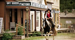
The Council Grove National Historic Landmark District includes numerous historic architectural scenery of the community. It includes the Last Chance Store, the oldest commercial building in Council Grove and the last opportunity for freighters bound for Santa Fe to pick up supplies. It includes Hays House, built in 1857 by townfounder, Seth Hays, the oldest restaurant west of the Mississippi, and the Post Office Oak and Museum where travelers left messages at the oak tree.
Directions
In Council Grove proceed north on the Byway to US 56. Turn west on US 56. Council Grove Convention and Visitors Bureau is on the north side of the first block west of K-177, and Bowers Center is two blocks west of K-177 on the south side of US 56.
Council Grove Reservoir (KS)
Council Grove Reservoir is a Corps of Engineers-created reservoir just north of Council Grove. The 3,310-acre reservoir includes 2,638 acre wildlife area at the upper end of the reservoir. The lake is in a very aesthetic setting of rolling bluestem hills trimmed with hickory, oak, walnut and elm trees along the streams. Birdwatching, interpretive sites, nature trails, as well as boating, fishing (handicap accessible fishing spots), camping are all part of this experience.
Directions
From the north end of the Byway, continue north approximately 2 miles on K-177. The reservoir is on the west side of the roadway.
Flint Hills Scenic Byway Kiosks (KS)
Byway kiosks are located in the four gateway communities along the Byway to convey stories of those communities and tie the beauty of each community of the Byway together. The kiosks provide photos and short descriptions of what there is to see and do in the Byway communities.
The Council Grove kiosk is half-block from the intersection of K-177 and US 56 in the southeast quadrant. The Strong City kiosk is located in Strong City Railroad Park on the Byway. The Cottonwood Falls kiosk is located in Bates Park on the Byway. The Cassoday kiosk is located one block east of K-177 in Cassoday on Bishop Street.
Flint Hills Tallgrass Prairie (KS)
The Byway is in the last largest contiguous remnant of Tallgrass Prairie left in North America. At one time, the Tallgrass Prairie comprised 142 million acres. Today, there is less than 4% of native prairie left, and two-thirds of that is in the Flint Hills of Kansas. The Byway traverses the heart of the Tallgrass Prairie throughout its length offering vista aftervista of the majesty and beauty of the prairie. The prairie shows nature at its best.
Kaw Mission State Historic Site and Museum (KS)
The Kaw Mission is a starting point for the Council Grove self-guided tour. Built in 1851, the mission served as a school for the Kaw Native American children. Learn of the intersection of cultures and gain a sense of place among the Flint Hills and the Tallgrass Prairie. It is a fine example of limestone architecture nestled on the Neosho River.
Directions
In Council Grove, proceed north from the end of the Byway, K-177 to US 56. Turn west on US 56 and go one block to Mission Street. Turn north on Mission Street. Kaw Mission is on the right approximately three blocks.
Lower Fox Creek School (KS)
This one-room school, on the Tallgrass Prairie National Preserve, stands as a beacon on the Flint Hills Scenic Byway. Its lonely presence on top of a windswept hill makes the vastness of the prairie even more compelling.
Neosho Riverwalk (KS)
The Neosho Riverwalk connects the Madonna of the Trail DAR statue depicting a pioneer mother and her two children, the Guardian of the Grove statue honoring the Kaw, the Neosho River Crossing (Santa Fe Trail crossing) and the Kaw Mission State Historic Site. This ADA accessible, lighted, landscaped walkway is a favorite gathering place for those who enjoy the serenity of nature. It becomes a seasonal delight when decorated for the Christmas holidays.
Directions
Proceed north from the end of the Byway on K-177 to the intersection with US 56. Continue north through the intersection to the Riverwalk parking area.
Santa Fe Bunkhouse (KS)
After the railroad reached Matfield Green in 1923, the Santa Fe Railway set up a system for maintenance section gangs to keep the tracks repaired. The railway built a series of section bunkhouses every 8-10 miles along the route. One of the few remaining houses is being restored just north of Matfield Green on the Byway. It will appear as it did in 1920s when it was built and will be turned into artists' studios. It is evocative of days gone by.

