Kansas Map

Facebook Twitter Google+
Follow The Go Travel Sites on Facebook

  • Places To Go

    A summary of what Hays has to offer.

    Summary list of destinations near Hays.

    Explore travel information for Kansas cities, towns, parks, regions and more.

    Coverage for every state in the United States.

    Explore neighboring countries (and soon countries throughout the world).

    Dodge City

    Wild West frontier town it might no longer be, but in Dodge City, the former home of the Earps and Mastersons, there are plenty of associated sights to see so long as you check your gun at the door.

  • Things To Do

    Searchable list of Hays tour companies, guides and outfitters, rental companies and more.

    Full information on Hays Tourist Attractions, Scenic Drives and other easy vacation activities…

    Detailed information on active pursuits in Hays such as biking, hiking, golfing and much more.

    Searchable lists of Hays museums, parks, galleries, and more.

    Introduction to all the things to do in Kansas.

    Searchable list of tour companies, guides and outfitters, rental companies and more.

    Full information on Tourist Attractions, Scenic Drives, Sightseeing Tours and easy vacation activities..

    Detailed information on active pursuits such as biking, hiking, golfing and much more.

    Museums, parks, galleries, zoos, and everything else you could want to do in Kansas.

    Things To Do

    Set off in search of the Wild West in Dodge City, track down historic sites in Topeka and catch cultural riverside activity in Witchita

    Learn More
  • Sleep + Eat

    Searchable listings of Hays hotels, motels, resorts, bed & breakfast, and more.

    Searchable listings of Kansas hotels, motels, resorts, bed & breakfast, and more.

    Searchable listings of Kansas RV parks and campgrounds.

    Lodging and Hotels

    Use our easy Lodging Search to find exactly the type of accommodation you are looking for at the right price.

    Search Now
  • Travel Planning

    Request Free Travel brochures for Hays.

    Transportation companies, driving directions and more for Hays.

    Hays weather report, historic temperatures and climate info,…

    Searchable lists of Hays tourism offices and other helpful government agencies.

    Explore destinations near Hays.

    Request Free Travel brochures from destinations throughout Kansas.

    Transportation companies, airports and interactive maps for Kansas.

    Travel and tourism books and maps for Kansas.

    Basic facts about Kansas, including a guide to every city and town in Kansas.

    Searchable lists of Kansas tourism offices and other helpful government agencies.

  • Photo Gallery

    Searchable slide shows of Kansas photos.

    Searchable slide shows of Kansas videos.

    Searchable slide shows of Hays photos.

    Photo and Video Gallery

    Browse photos and videos from across the state, take a virtual tour, search for the imagery you want to see.

    View Now
  • Map It!

Smoky Valley Scenic Byway

No Media or Maps Available
If you are the owner/manager of this business and would like to improve your listing, please submit a request.
Basics
Length:
60 miles (96 km)
Fees:
None.

Description

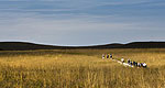
The Smoky Valley Scenic Byway takes the traveler through 60 miles of west central Kansas through the Smoky Hill River Valley. Named for their "hazy" appearance at sunrise and sunset, the Smoky Hills provide a transition between the mixed-grass prairie and the short-grass prairie of the plains. The byway offers a showplace of native wildflowers and grasses through the seasons. Coneflowers, yucca, Indian blanket and sky blue pitcher sage abound. In addition, the croplands provide a panorama of vegetation from the emerald green of winter wheat to the rich russet red of milo. Rock outcroppings hint of the layers of stone left by the inland sea millions of years ago.

Westward bound pioneers crossed this area as they traversed the Smoky Hill Trail. The Butterfield Overland Despatch, established at the end of the Civil War, originally carried freight then passengers from Fort Leavenworth to Denver. Today limestone markers identify two of its crossings along the byway.

Threshing Machine Canyon near Cedar Bluff State Park and Reservoir is the site of an 1867 Native American attack on a wagon train transporting a threshing machine to Brigham Young in Salt Lake City. Smoky Hill Trail travelers carved their names in the canyon walls.

Named for the 100-foot tall, cedar-covered limestone bluffs along the south side of the Lake, the Cedar Bluff State Park and Reservoir is a great place to camp, hike, fish, view wildlife, birdwatch, boat, play volleyball and horseshoes. The Reservoir hosts many fishing tournaments and other special events throughout the year including "The Gather in," a Celtic celebration of the ancient holiday Beltane (May Day) with foods, games and music.

Tourism Resources

Length:
60 miles (96 km)
Main Roads:
US-283 S and KS-147 N
Fees:
None.
Customizable Directions

Formatted DirectionsMap

Email Page Link

Complete the form below to email this page to a friend or family member's email. You can send yourself an email as well. Your email and your recipient's email will NOT be shared with anyone. See our full Privacy Policy for details.
:
:
:


:
Copy Yourself on the Email Yes No
:
: